APPLES IN HEAD TIDE · PANEL I
Status note: The Apples in Head Tide exhibit's physical installation at the Head Tide Store, 45 Head Tide Road, Alna, is in preparation. Opening date to be announced — these pages are live in advance of the physical exhibit and will remain as its permanent online companion.
The Orchards on the Hill
On the hillside above Head Tide, apple trees once climbed in parallel rows toward the ridge.
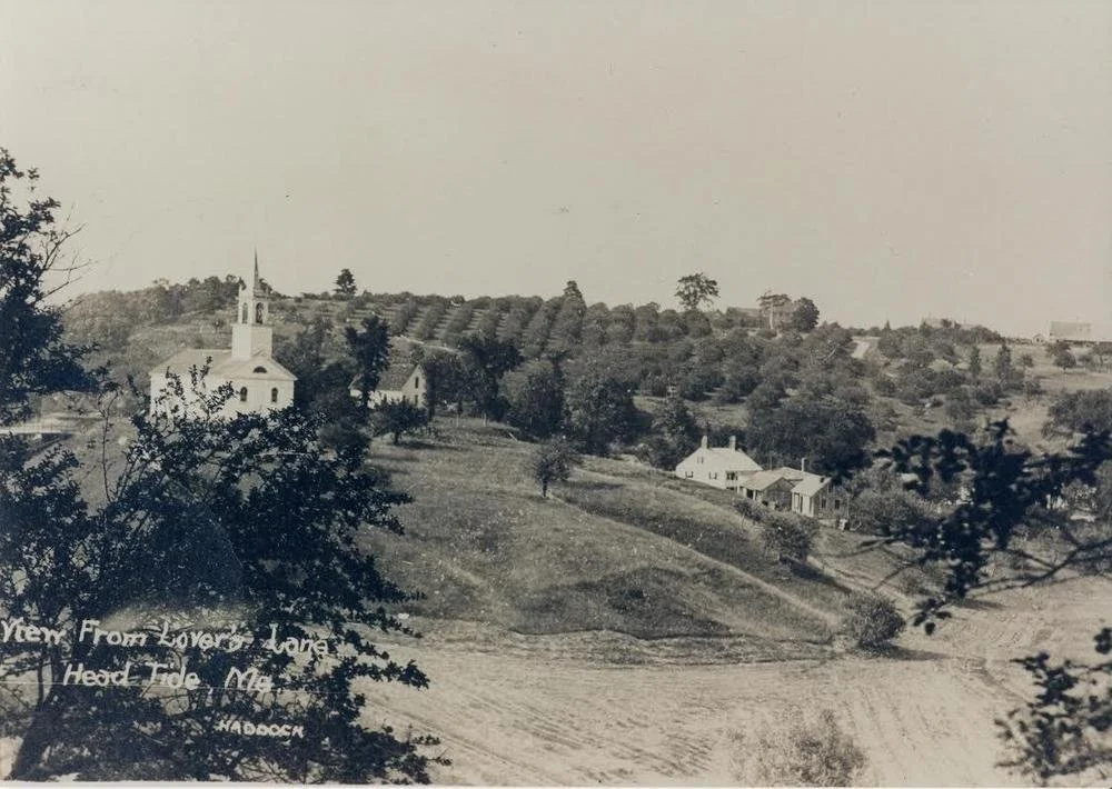
View from Lover's Lane, Head Tide, Maine, c. 1910–1930. Real-photo postcard by a photographer credited as "Haddock." The Head Tide Church and the one-room schoolhouse stand at left; village houses sit just below, and parallel rows of apple trees climb the hillside in the middle distance. Image courtesy of the Wiscasset, Waterville and Farmington Railway Museum, via Bruce Wilson.
The hillsides behind the site where the mill once stood were well suited to fruit growing, and the Sheepscot Valley's climate — cold winters, warm summers, good drainage — produced apples of exceptional quality. Orchards were once as central to the New England farm as the farmhouse itself.
As Maine apple historian John Bunker has observed, "at a certain point, everyone had an orchard" — everyone lived on a farm, and every farm had an orchard. Head Tide was no exception. Maine apples reached markets up and down the East Coast and beyond, and Head Tide's orchards were a small part of that larger story.
That orchard was still vivid in living memory a half-century on. Nina Cheney, who came to Head Tide in 1921, recalled it for a 1978 oral-history interview by Alna native Michael Chaney: "The Jewetts had a large orchard — a nice apple orchard. They employed a lot of people at picking time in the fall of the year." Her husband, Albro, went up to pick, and so did many of the neighborhood women — a reminder that an orchard of this scale was also a seasonal employer.
LISTEN — ORAL HISTORY, 1978
Nina Cheney — the Jewett orchard
NA1200 Nina Cheney, interviewed by Michael Chaney, 20 June 1978. Special Collections, Raymond H. Fogler Library, University of Maine, "MF030 Lincoln County Project / Leighton Photo Collection." Northeast Archives of Folklore and Oral History, University of Maine.
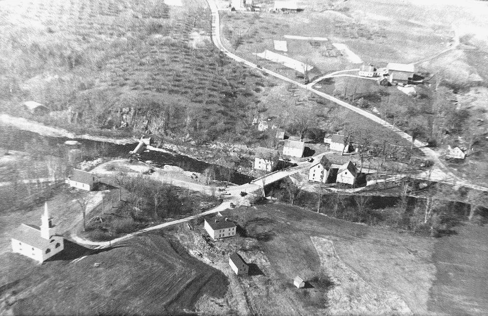
The same orchards a generation later — aerial photograph of Head Tide, c. 1949–1955. The Head Tide Church and the one-room schoolhouse are visible at the left edge of the frame; the 1949 Head Tide bridge appears in the foreground. The orchards on the hillside above the village are still discernible from above but were by then nearing the end of their commercial life. From the Town of Alna archives.
[Nina Cheney, a Head Tide resident from 1921, interviewed by Michael P. Chaney, June 29, 1978; Northeast Archives of Folklore and Oral History, accession 1200.1. Quotation lightly cleaned from the interview transcript.]
[The Lover's Lane photograph is a real-photo postcard by a photographer credited as "Haddock," dated approximately 1910–30 based on style and content. Precise dating awaits inspection of the original card, believed to be held in the Wiscasset, Waterville and Farmington Railway Museum collection. The date range for the aerial photograph is based on the 1949 construction of the Head Tide bridge (visible in the image) and a neighbor's estimate placing it no later than the mid-1950s based on which buildings are present. The provenance of the aerial photograph — who took it and for what purpose — remains under investigation.]
[The broader claim about Maine apple exports is supported by our own collection documents (commission-merchant correspondence from Boston, 1908; bills of lading to Portland and New York, 1930–31) but we have not yet identified a scholarly source for the scale and geography of Maine's apple export trade in this period.]
Sources: View from Lover's Lane, Head Tide, Maine, photographer credited "Haddock," c. 1910–30, image courtesy of the Wiscasset, Waterville and Farmington Railway Museum, via Bruce Wilson. Aerial photograph of Head Tide, c. 1949–1955, Town of Alna archives. John Bunker, quoted in New England Historical Society. Head Tide bridge (MDOT Bridge No. 5179, year built 1949). Neighbor estimate courtesy Gerry Flanagan, April 2026. Nina Cheney, oral-history interview by Michael P. Chaney, June 29, 1978, NAFOH accession 1200.1.